Sea ice has
a major impact on albedo in the Arctic region.
The positive NAM/NAO phase is connected with drier winters in western
Greenland. Many models show a decrease
in the Arctic ice volume over the past few decades. In many models there has been a stable
increase in northern high-latitude temperatures.
These simulations show that the annual mean of Arctic warming is well
beyond the global warming average by about 2 in the models. It is predicted that by the end of the century,
the annual warming of the Arctic will be 5 degrees Celsius. Seasonal extent of temperature is greater
over water due to the melting ice caps in the summer. It is predicted that by the end of the
century, the mean warming range will be 4.3°C to 11.4°C in the winter and 1.2°C to
5.3°C in summer. Some models show an increase
in precipitation by the end of the century.
There is a 5% precipitation increase for every one degree increase in temperature;
the greatest increase will be over the Arctic Ocean. At the end of the century, the annual mean precipitation
in the Arctic will experience a change of 10% to 28%, with the largest increase
in winter months.
Information taken from: http://www.ipcc.ch/publications_and_data/ar4/wg1/en/ch11s11-8-1.html
The main issues
surrounding the Arctic region are the decline of glaciers and ice sheets, the decrease
in coastal surface area and decline in sea ice.
In Greenland, due to major declines in ice sheets there will be numerous
reductions in coast lines and low-lying areas.
This will cause many economic concerns, including but not limited to,
population relocation. Temperatures in this
region have risen 1-4 degrees Celsius causing an average rise of 4-6m in sea
level. If Greenland’s ice sheets were to
completely melt the increase in sea level would be 5m. The average rise of the sea level can lead to
many complications apart from population relocation, it can cause a reduction
in freshwater rivers causing a shortage in freshwater.
Information taken from: http://www.ipcc.ch/publications_and_data/ar4/wg2/en/spmsspm-d.html
Climate
change is casing many complications in the Arctic region. It is expected that albedo will decrease;
there will be a larger accumulation of carbon and methane causing permafrost to
melt. However, there have been models
that show that in some parts of the Arctic there has been an increase in
prosperity among wildlife and plants.
The impact that climate change will have on fisheries in the Arctic will
both be harmful and beneficial. It was
noted that the decline in Arctic ice sheets have led to better marine access
but detrimental effects to organisms dependent upon the ice sheets. In the past few decades the average surface
temperature of the Arctic has increased at almost double that of the global
rate. Warming in the Arctic is most extreme
in the winter and the spring. As a
result of the decline in coastal ice sheets, there have been an increase in
storms along the coast.
Information taken from: http://www.ipcc.ch/publications_and_data/ar4/wg2/en/ch15s15-2.html
The most interesting and detrimental threat to Greenland is
the melting of the polar ice sheets. This
has a major impact on the sea level, as the ice sheets melt the average ocean
level rises causing coastal flooding, which could severely impact communities
in that area. Apart from that, many
organisms in Greenland rely on the ice sheets to maintain their
livelihood. Another major concern is the
melting of permafrost which can create an unstable infrastructure, and also
cause population relocation. Also, with
the decline of coastal areas, there is a threat of freshwater sources being
contaminated, which could limit the amount of fresh water available to the
region. Many of these issues surrounding
the melting of the ice sheets have significant economical complications.
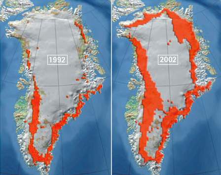
Image taken from: http://www.solarnavigator.net/images/climate_chaos_greenland_arctic_climate_impact_assessment_1992_2002.jpg
The image above illustrates the decline in ice sheets over the Greenland region from 1992 to 2002; this is a direct result of climate change.
Although, this image might be a bit of an exaggeration of current conditions in Greenland, it nonetheless illustrates the impact the melting ice sheets have on the habitats of certain species in that area.
